Time for a new virtual journey and our first trip to North America! Off to 66.08° N, 106.93° W. Be sure to bundle up! This will be a relatively short one.
Physical geography:
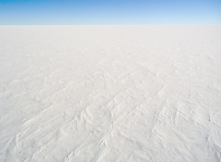
We're on a lake, a decent sized lake too, about 2 square kilometers, or 500 acres. Sadly this lake doesn't even have a name though as it's surrounding be literally thousands of other lakes just like it. We're on the Canadian Shield, a huge area of mostly bare rock and lakes carved by the giant ice sheet that covered the area for thousands of years. The rock is among the oldest on the earth, having sat here largely unchanged for 2-3 billion years. Water from this lake flows from a chain of similarly unnamed streams and lakes for about 2 miles before reaching the Western river and then 35 miles to the Bathurst Inlet, itself an arm of the Coronation Gulf that connects the Beaufort Sea to the Arctic Ocean - part of the infamous Northwest Passage. While there are not mountains here, it's not exactly what I'd call flat either, the lake is about 1,000 feet about sea level, and the surrounding rocks are very craggy with lots of steep ravines. That 2 mile trip to the Western river sees about 750 feet of elevation change.

This lake might be frozen more often than not, we're only about 30 miles south of the Arctic Circle. There aren't any weather stations particularly close, but I'd guess the winter temperatures are often hovering around 0° F, warming up to the 60's and 70's in summer. Precipitation happens year round, plenty of snow in the winter, spring, and fall, and rain in the summer and windy and cloudy most of the time.
Ecology here is tundra, definitely too far north for trees, vegetation where there is any at all is mostly moss and lichens, maybe some grasses and low shrubs. There are however plenty of critters like wolves and bears and many smaller critters. Of note this is prime caribou habitat and one known herd goes through the area, the herd is been shrinking dramatically and is now being protected.

Human geography:
We are in the Kitikmeot Region of Nunavut, Canada. This is however another point that may very well have never seen a human being. Nunavut is sparsely populated to begin with, and this is the least populated section. There isn't even a road within 200 miles. Historically this area would've been populated by Inuit peoples, though even they wouldn't normally be this far inland unless they were chasing a herd of caribou.
The British claimed the area in the 1800's and in theory included it in the area that the Hudson's Bay Company administered, but they never came here during that period. The closest European's got was Franklin's doomed expedition and that was still over 300 miles away. The area would become part of Canada in 1870 still never having been visited by non-Inuit. The Hudson's Bay Company would finally come to the area in 1936, along with some Catholic missionaries, founding what would be the closest settlement to our point, Bathurst Inlet (or Qingaut or Kingaun or Kingoak), about 60 miles away, catering to the local Inuit. They have since abandoned it and now it doesn't have a permanent population, its official census count is 0. It does have a seasonal population in the summer though and both the former trading post and church have been incorporated into a lodge catering to ecotourists. There may also be Inuit in the area living a traditional, migratory, lifestyle not captured by the census.
The locals are still primarily Inuit, Nunavut was created in 1999 to give the Inuit a degree of self-government and they form the majority throughout the territory. The group closest to our point are the Copper Inuit, who traditionally spoke Inuinnaqtun, one of the official languages of Nunavut, although most now speak English, only 495 people reported using Inuinnaqtun as their primary language in the last census. Inuinnaqtun uses the Roman alphabet rather than the syllabics that some of the other Inuit languages use. Most Inuit now believe in some variety of Christianity, though a tiny minority do hold the traditional shamanistic beliefs.
As you might guess this place is pretty isolated, Bathurst Inlet does have an airstrip you can reach if you charter an airplane - possible in either Cambridge Bay, which is the only town of any size in Kitikmeot at 1,766 people and on the other side of Coronation Gulf, 210 miles away; or more likely from Yellowknife, capital in neighboring Northwest Territories 340 miles away and with connections to the rest of the world.
Bathurst Inlet might not be the closest people to our point though. The other economic activity in the area besides ecotourism is mining, primarily silver and gold, and there are two mining sites between 30-40 miles away from our point to the south. These are new and as far as I can tell neither is in production yet, they are still in the exploration and building infrastructure stage. Currently those are supplied by air, but I found one report of a new port being built. I couldn't find any trace of that port on the satellite imagery, but if it is where this map says it is than it would be another contender for closest human activity to our point at around 40 miles away and there would be a possibility of a road being built to connect the mines to the port that would come much closer (our point being about 1/2 way in between - though closer to the Western river than any likely route). Similar proposed projects have had difficulty actually getting built due to their expanse and concerns about the impact on the caribou.

Since it seems on topic, I'll leave you with a couple of songs:
Northwest Passage:
https://www.youtube.com/watch?v=TVY8LoM47xI
Lord Franklin
https://www.youtube.com/watch?v=Kj4RHYJdcE4
Physical geography:
We're on a lake, a decent sized lake too, about 2 square kilometers, or 500 acres. Sadly this lake doesn't even have a name though as it's surrounding be literally thousands of other lakes just like it. We're on the Canadian Shield, a huge area of mostly bare rock and lakes carved by the giant ice sheet that covered the area for thousands of years. The rock is among the oldest on the earth, having sat here largely unchanged for 2-3 billion years. Water from this lake flows from a chain of similarly unnamed streams and lakes for about 2 miles before reaching the Western river and then 35 miles to the Bathurst Inlet, itself an arm of the Coronation Gulf that connects the Beaufort Sea to the Arctic Ocean - part of the infamous Northwest Passage. While there are not mountains here, it's not exactly what I'd call flat either, the lake is about 1,000 feet about sea level, and the surrounding rocks are very craggy with lots of steep ravines. That 2 mile trip to the Western river sees about 750 feet of elevation change.
This lake might be frozen more often than not, we're only about 30 miles south of the Arctic Circle. There aren't any weather stations particularly close, but I'd guess the winter temperatures are often hovering around 0° F, warming up to the 60's and 70's in summer. Precipitation happens year round, plenty of snow in the winter, spring, and fall, and rain in the summer and windy and cloudy most of the time.
Ecology here is tundra, definitely too far north for trees, vegetation where there is any at all is mostly moss and lichens, maybe some grasses and low shrubs. There are however plenty of critters like wolves and bears and many smaller critters. Of note this is prime caribou habitat and one known herd goes through the area, the herd is been shrinking dramatically and is now being protected.
Human geography:
We are in the Kitikmeot Region of Nunavut, Canada. This is however another point that may very well have never seen a human being. Nunavut is sparsely populated to begin with, and this is the least populated section. There isn't even a road within 200 miles. Historically this area would've been populated by Inuit peoples, though even they wouldn't normally be this far inland unless they were chasing a herd of caribou.
The British claimed the area in the 1800's and in theory included it in the area that the Hudson's Bay Company administered, but they never came here during that period. The closest European's got was Franklin's doomed expedition and that was still over 300 miles away. The area would become part of Canada in 1870 still never having been visited by non-Inuit. The Hudson's Bay Company would finally come to the area in 1936, along with some Catholic missionaries, founding what would be the closest settlement to our point, Bathurst Inlet (or Qingaut or Kingaun or Kingoak), about 60 miles away, catering to the local Inuit. They have since abandoned it and now it doesn't have a permanent population, its official census count is 0. It does have a seasonal population in the summer though and both the former trading post and church have been incorporated into a lodge catering to ecotourists. There may also be Inuit in the area living a traditional, migratory, lifestyle not captured by the census.
The locals are still primarily Inuit, Nunavut was created in 1999 to give the Inuit a degree of self-government and they form the majority throughout the territory. The group closest to our point are the Copper Inuit, who traditionally spoke Inuinnaqtun, one of the official languages of Nunavut, although most now speak English, only 495 people reported using Inuinnaqtun as their primary language in the last census. Inuinnaqtun uses the Roman alphabet rather than the syllabics that some of the other Inuit languages use. Most Inuit now believe in some variety of Christianity, though a tiny minority do hold the traditional shamanistic beliefs.
As you might guess this place is pretty isolated, Bathurst Inlet does have an airstrip you can reach if you charter an airplane - possible in either Cambridge Bay, which is the only town of any size in Kitikmeot at 1,766 people and on the other side of Coronation Gulf, 210 miles away; or more likely from Yellowknife, capital in neighboring Northwest Territories 340 miles away and with connections to the rest of the world.
Bathurst Inlet might not be the closest people to our point though. The other economic activity in the area besides ecotourism is mining, primarily silver and gold, and there are two mining sites between 30-40 miles away from our point to the south. These are new and as far as I can tell neither is in production yet, they are still in the exploration and building infrastructure stage. Currently those are supplied by air, but I found one report of a new port being built. I couldn't find any trace of that port on the satellite imagery, but if it is where this map says it is than it would be another contender for closest human activity to our point at around 40 miles away and there would be a possibility of a road being built to connect the mines to the port that would come much closer (our point being about 1/2 way in between - though closer to the Western river than any likely route). Similar proposed projects have had difficulty actually getting built due to their expanse and concerns about the impact on the caribou.
Since it seems on topic, I'll leave you with a couple of songs:
Northwest Passage:
https://www.youtube.com/watch?v=TVY8LoM47xI
Lord Franklin
https://www.youtube.com/watch?v=Kj4RHYJdcE4


