Taking a break from the news, time to take a little virtual journey to: 32.53° N, 65.49° E.
Physical geography:
This point brings us to central Asia on the slopes of a mountain called Tōr Ghwênḏ around 5,000 feet above sea level. It's part of a range of mountains forming the edge of the Helmand River valley, which themselves are part of the larger Hindu Kush range. The Helmand is somewhat similar to the Nile, a narrow ribbon of lushness through an otherwise barren desert environment. Though in this case a mountainous desert. The ribbon of green along the river is about a mile wide, surrounded by a roughly 10 mile wide, 20 mile long, mostly barren plain, and then the mountains. There are a bunch of usually dry streambeds running between the mountains and the Helmand.
It is hot and dry here, though not to the extremes of some of our past points, more steppe-like than true desert due to the elevation. Yearly rainfall is about 8 inches, mostly in the winter. Temps are in the 80's in the summer, sometimes going in the 100's, and in the 40's in the winter, occasionally dipping below freezing. There does not appear to be anything at all growing here, just sand and rock, though it's possible there is some grass. I wasn't able to find out much about the local wildlife, though I'd assume you'd get the usual little desert critters.
The primary environmental threat to the area is drought, it being highly dependent on the single source of water, and there are been some nasty ones in recent years, 2001-2003 and again in 2018-1019 causing serious food supply issues.

Human geography:
As you may have guessed we are in Afghanistan, specifically the Deh Rahwood district of the Uruzgan province in the middle of the country, giving us our first point in an active war zone. There's not much data for this part of the world so a lot of what follows is conjecture. Our point is only 2 miles to the dirt road that connects this valley to the rest of the world, 4 miles to the nearest settlement at Zar Tala, and 5 to the string of settlements along the Helmand. Those have a pattern we don't really see in the U.S., a densely populated rural area. Usually you think densely populated means cities, but here there's no hub, none of the commercial activity associated with towns, just lots of little farms packed together, mostly growing wheat and opium poppies. Zar Tala is a little off the river and utilizes irrigation from buried channels that capture what little rainfall the area gets and grows orchards of almonds and apricots. The area does have livestock as well, but that has taken a big hit from the recent droughts. The district capital of Deh Rahwood is the largest of those towns along the Helmand, also only about 5 miles away, population probably in the tens of thousands, but lacking paved roads or electricity. The provincial capital of Tarinkot is 20 miles to the east, but might as well be a million miles away as there is a roadless Taliban-infested mountain range in between. This valley's one road leads to the south for a 70 mile, 3 hour, journey to Kandahar the nearest major city. Kandahar is also the market for the agriculture grown here, most of the locals never leave, merchants from Kandahar make the journey, buy or barter what they're interested in and make the trek back. (summary of Uruzgan economy).
The people here are Pashtuns, the largest ethnic group in Afghanistan and more or less synonymous with the ethnic group historically called Afghans, and have been here for basically all of recorded history. They have a tribal organization, and there are hundreds of different, largely independent, tribes, but it was not clear which tribes lived in this particular valley. I'm assuming they primarily speak Pashto (aka Afghani) which is the native language of the Pashtuns and the most common language in Kandahar. That is not the dominant language of Afghanistan which is Dari (Persian), but we're close to the heart of Pashtun country and very isolated while Dari is more common among the country's elite. The religion is universally Sunni Islam and the local mosque is likely the primary institution in Deh Rahwood.
Afghanistan has a long history of being conquered by other peoples who don't stay once they realize how inhospitable it is, dating back to Alexander the Great who founded the city that what would become Kandahar with the area usually being ruled by Indian or Persian dynasties. The Arabs conquered the area in the 7th century and while they didn't stay their religion did with Islam replacing the earlier Zoroastrian and Buddhist beliefs. The Mongols conquered the area in the 1200's and ruled for about 100 years before it went back to being traded between Persian and Indian empires.
The Afghans won their independence in 1747 and Kandahar became the center of the Afghan Empire which ruled modern-day Afghanistan and Pakistan forming the predecessor to modern Afghanistan. It collapsed into smaller states in civil war during the 1820's. The British soon became interested, they conquered most of India and were worried about containing Russia. Their first invasion of Afghanistan in 1839 was a complete disaster, one of the few outright defeats of a colonial power. They didn't try again until 1878 which saw a very bloody war ending with a decisive British victory at Kandahar and Afghanistan agreed to became a protectorate, but the British troops did not stay due to constant rebellions. Afghanistan won its independence again in 1919 fighting yet another war against the British, the British held the advantage militarily, but were exhausted from WWI and also involved in the Russian Civil War and settled for retaining what is now Pakistan, establishing the modern Afghan-Pakistan border that runs through the middle of Pashtun territory.
The region would again be engulfed in war during the 80's and the Soviet-Afghan War and the succession of civil wars following that continue to this day. The Soviet war was complicated, to put it mildly, but one of the inspirations of the Mujahideen resistance was that they saw the Soviet style reforms as an attack on Islam. The Pashtun tribes formed the core of the Mujahideen and when the Soviets took the cities, our rural middle of nowhere valley became a stronghold. Deh Rahwood has one famous person from it, Mohammed Omar. Omar fought against the Soviets and after the pro-Soviet regime fell defeated rival Mujahideen leaders and formed the Taliban, taking Kandahar in 1996 and Kabul in 1996. He ruled Afghanistan until deposed by the U.S. led coalition invasion in 2001 for harboring Osama Bin Laden, and after that continued to lead the insurgency against the new Afghan government until his death in 2013. Our valley continued to be a Taliban stronghold and was one of the areas the Taliban retreated to when driven out of power in order to regroup. The Afghan government took Kandahar in 2003, but the countryside of southern Afghanistan hasn't seen peace since the 70's.
For the area in the immediate vicinity of our point, I believe coalition forces bombed the area in 2002-2003 and then later established a ground presence with a base for the Dutch military in Deh Rahwood from 2006-2010. As an indicator of how isolated this valley is, when the Dutch first arrived the locals had feared the Soviets were returning. The Dutch were able to take control of the valley, but the Taliban continue to operate in the mountains. The Taliban conducted mass executions near Deh Rahwood in 2008 that turned many of the locals against them and after that they sided with the Coalition forces. The Dutch also conducted numerous infrastructure projects in the area (detailed report on the Dutch mission).
I can't tell if the Taliban have moved back in since the Dutch have left, the province as a whole has rival governors appointed, but not sure either of them has much authority here, the Dutch reported no functioning local government and what authority there is seems to be in the hands of local tribes. There have still been reports of fighting as recently as last year.
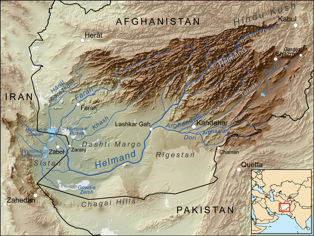
I'll leave you with a map I made of the Helmand drainage basin, with our point being near where the Helmand starts going through the mountains.
Physical geography:
This point brings us to central Asia on the slopes of a mountain called Tōr Ghwênḏ around 5,000 feet above sea level. It's part of a range of mountains forming the edge of the Helmand River valley, which themselves are part of the larger Hindu Kush range. The Helmand is somewhat similar to the Nile, a narrow ribbon of lushness through an otherwise barren desert environment. Though in this case a mountainous desert. The ribbon of green along the river is about a mile wide, surrounded by a roughly 10 mile wide, 20 mile long, mostly barren plain, and then the mountains. There are a bunch of usually dry streambeds running between the mountains and the Helmand.
It is hot and dry here, though not to the extremes of some of our past points, more steppe-like than true desert due to the elevation. Yearly rainfall is about 8 inches, mostly in the winter. Temps are in the 80's in the summer, sometimes going in the 100's, and in the 40's in the winter, occasionally dipping below freezing. There does not appear to be anything at all growing here, just sand and rock, though it's possible there is some grass. I wasn't able to find out much about the local wildlife, though I'd assume you'd get the usual little desert critters.
The primary environmental threat to the area is drought, it being highly dependent on the single source of water, and there are been some nasty ones in recent years, 2001-2003 and again in 2018-1019 causing serious food supply issues.
Human geography:
As you may have guessed we are in Afghanistan, specifically the Deh Rahwood district of the Uruzgan province in the middle of the country, giving us our first point in an active war zone. There's not much data for this part of the world so a lot of what follows is conjecture. Our point is only 2 miles to the dirt road that connects this valley to the rest of the world, 4 miles to the nearest settlement at Zar Tala, and 5 to the string of settlements along the Helmand. Those have a pattern we don't really see in the U.S., a densely populated rural area. Usually you think densely populated means cities, but here there's no hub, none of the commercial activity associated with towns, just lots of little farms packed together, mostly growing wheat and opium poppies. Zar Tala is a little off the river and utilizes irrigation from buried channels that capture what little rainfall the area gets and grows orchards of almonds and apricots. The area does have livestock as well, but that has taken a big hit from the recent droughts. The district capital of Deh Rahwood is the largest of those towns along the Helmand, also only about 5 miles away, population probably in the tens of thousands, but lacking paved roads or electricity. The provincial capital of Tarinkot is 20 miles to the east, but might as well be a million miles away as there is a roadless Taliban-infested mountain range in between. This valley's one road leads to the south for a 70 mile, 3 hour, journey to Kandahar the nearest major city. Kandahar is also the market for the agriculture grown here, most of the locals never leave, merchants from Kandahar make the journey, buy or barter what they're interested in and make the trek back. (summary of Uruzgan economy).
The people here are Pashtuns, the largest ethnic group in Afghanistan and more or less synonymous with the ethnic group historically called Afghans, and have been here for basically all of recorded history. They have a tribal organization, and there are hundreds of different, largely independent, tribes, but it was not clear which tribes lived in this particular valley. I'm assuming they primarily speak Pashto (aka Afghani) which is the native language of the Pashtuns and the most common language in Kandahar. That is not the dominant language of Afghanistan which is Dari (Persian), but we're close to the heart of Pashtun country and very isolated while Dari is more common among the country's elite. The religion is universally Sunni Islam and the local mosque is likely the primary institution in Deh Rahwood.
Afghanistan has a long history of being conquered by other peoples who don't stay once they realize how inhospitable it is, dating back to Alexander the Great who founded the city that what would become Kandahar with the area usually being ruled by Indian or Persian dynasties. The Arabs conquered the area in the 7th century and while they didn't stay their religion did with Islam replacing the earlier Zoroastrian and Buddhist beliefs. The Mongols conquered the area in the 1200's and ruled for about 100 years before it went back to being traded between Persian and Indian empires.
The Afghans won their independence in 1747 and Kandahar became the center of the Afghan Empire which ruled modern-day Afghanistan and Pakistan forming the predecessor to modern Afghanistan. It collapsed into smaller states in civil war during the 1820's. The British soon became interested, they conquered most of India and were worried about containing Russia. Their first invasion of Afghanistan in 1839 was a complete disaster, one of the few outright defeats of a colonial power. They didn't try again until 1878 which saw a very bloody war ending with a decisive British victory at Kandahar and Afghanistan agreed to became a protectorate, but the British troops did not stay due to constant rebellions. Afghanistan won its independence again in 1919 fighting yet another war against the British, the British held the advantage militarily, but were exhausted from WWI and also involved in the Russian Civil War and settled for retaining what is now Pakistan, establishing the modern Afghan-Pakistan border that runs through the middle of Pashtun territory.
The region would again be engulfed in war during the 80's and the Soviet-Afghan War and the succession of civil wars following that continue to this day. The Soviet war was complicated, to put it mildly, but one of the inspirations of the Mujahideen resistance was that they saw the Soviet style reforms as an attack on Islam. The Pashtun tribes formed the core of the Mujahideen and when the Soviets took the cities, our rural middle of nowhere valley became a stronghold. Deh Rahwood has one famous person from it, Mohammed Omar. Omar fought against the Soviets and after the pro-Soviet regime fell defeated rival Mujahideen leaders and formed the Taliban, taking Kandahar in 1996 and Kabul in 1996. He ruled Afghanistan until deposed by the U.S. led coalition invasion in 2001 for harboring Osama Bin Laden, and after that continued to lead the insurgency against the new Afghan government until his death in 2013. Our valley continued to be a Taliban stronghold and was one of the areas the Taliban retreated to when driven out of power in order to regroup. The Afghan government took Kandahar in 2003, but the countryside of southern Afghanistan hasn't seen peace since the 70's.
For the area in the immediate vicinity of our point, I believe coalition forces bombed the area in 2002-2003 and then later established a ground presence with a base for the Dutch military in Deh Rahwood from 2006-2010. As an indicator of how isolated this valley is, when the Dutch first arrived the locals had feared the Soviets were returning. The Dutch were able to take control of the valley, but the Taliban continue to operate in the mountains. The Taliban conducted mass executions near Deh Rahwood in 2008 that turned many of the locals against them and after that they sided with the Coalition forces. The Dutch also conducted numerous infrastructure projects in the area (detailed report on the Dutch mission).
I can't tell if the Taliban have moved back in since the Dutch have left, the province as a whole has rival governors appointed, but not sure either of them has much authority here, the Dutch reported no functioning local government and what authority there is seems to be in the hands of local tribes. There have still been reports of fighting as recently as last year.
I'll leave you with a map I made of the Helmand drainage basin, with our point being near where the Helmand starts going through the mountains.