Entry tags:
Point #9: 39.92° N, 119.91° E
Time for a new random point: 39.92° N, 119.91° E.
My actual next point (#8) was 59° S, 105° E which was another Antarctica point, about 50 miles south of Vostok and an environment essentially the same as point #4, only a little more likely to be visited by Russians, so rather than repeat that we'll go on to somewhere more interesting.
Physical geography:
1,000 miles, almost due south, from our Siberian point, and we're in another world. This is technically an ocean point, but it's in the harbor of the world's largest coal port, so I think it'll be interesting. Located 3 miles off the coast in the Bohai Sea, itself a bay of the Yellow Sea, which is part of the Pacific Ocean. The coast here is a thin strip of flat land connecting the North China Plain that is the heart of China to the Manchurian plan to the northeast. The Yan mountains that separate them come to within 5 miles of the coast. The ecology here is now thoroughly urban, I'm sure that once upon a time there was a string of fishing villages here, but now the Bohai Sea no longer supports a fishery thanks to pollution. There are numerous rivers running between the mountains and the coast, the closest to our point being the Shihe River. The climate climate here is cold and dry in the winters with winds coming out of Siberia and getting into 20s, and hot and humid in the summer with monsoons coming off the ocean and bringing temperatures into the 80s.

Human geography:
Today this area is part of Qinhuangdao, a metropolis of 3 million people and the largest port city in the Hebei province of China. The section nearest our point is Shanhaiguan or Shanhai Pass, the name of the pass between the mountains and the ocean here. Before the unification of China this area was part of the Yan State, the last section of China to be conquered by Qin Shi Huang before he declared himself an emperor in 221 BC. Qin Shi Huang was obsessed with becoming immortal and his quest started in Qinhuangdao, he gave the city its name and outfitted an expedition here under the direction of his alchemist XuFu that would lead to the other side of the Bohai Sea. XuFu would abscond with the fleet never to return and Qin Shi Huang died young of mercury poisoning.
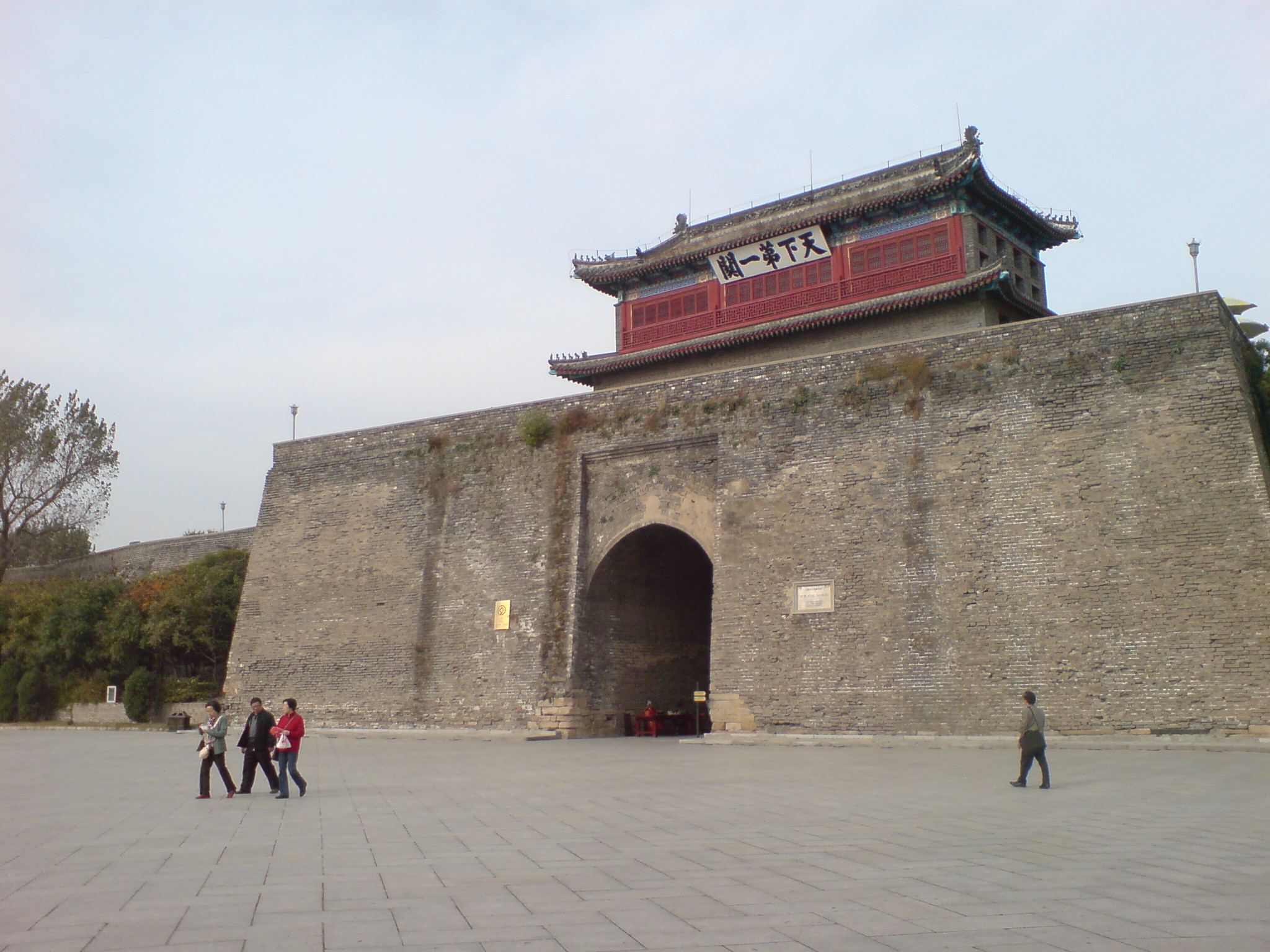
Because of the strategic importance of Shanhai Pass, this area was often fought over in China's many civil wars. In 1381 the Ming Dynasty built the Great Wall across the pass and built the walled city of Shanhaiguan to garrison its eastern end where it met the ocean. Where the Wall enters the sea is called the "Old Dragon Head" due to its appearance. I mentioned in our last point the Manchu conquest of China, it was right here that the critical battle in that conquest took place. In 1644 Ming general Wu Sangui was on what looked to be the losing side of a civil war, he retreated from Beijing to Shanhaiguan. He agreed let a Manchu army through the Great Wall if they'd help his side, they agreed to help if he'd swear allegiance to them instead of the Ming. He did and they crushed the Ming army that had been pursuing him and from there were unopposed in taking Beijing and founding the Qing Dynasty. Battle of Shanhai Pass.
Industrialization came to the area in the 1890's when China's first rail line running from Beijing towards Manchuria reached Shanhaiguan in 1893. In 1989 China established both an industrial port and the Beidaihe summer beach resort that was open to foreigners in Qinhuangdao. The 1890's also saw increasing interest in China from Colonial powers and anti-foreigner resentment exploded into the Boxer rebellion in 1899. British forces occupied Shanhaiguan to take control of the railway and to prevent the Russians from expanding their sphere of influence beyond Manchuria. The British would keep control of the railway until 1902.
In 1933, in events leading up to WWII, Shanhaiguan again saw battle as Japanese forces seized control of the Great Wall entrance, defeating the Chinese and forcing China to recognize their puppet state of Manchukuo and create a demilitarized buffer area inside the Great Wall leaving China proper without good defensive positions. The area would be occupied by Japan as a part of that buffer zone through till the end of the war in 1945. After the Japanese surrender the area was quickly occupied by communist forces and became part of the People's Republic of China. The communists kept the beach resort at Qinhuangdao, turning it into a summer retreat for senior party members, it became China's equivalent to Camp David.
The people here are almost entirely Han Chinese, though there is still a Manchu minority (3%). The language is Mandarin, the religion the typical Chinese mix of Buddhism, Confucianism, Taoism, and folk religion. Overall the culture is what has become viewed as the standard Chinese culture centered on Beijing.
China has continued to encourage industrial development in the area, in 1978 they declared Qinhuangdao one of their "open cities" open to foreign investment. The port is the worlds largest coal shipping port, shipping 244 million tons per year with plans for expanding. In addition the city is big in the glass, aluminum, auto industries, and manufacturing in general. The land closest to our point appears to be a major ship building plant/dry dock engaged in a large land reclamation project extending out into the Bay. The rail line is still here now served by the bullet train which will get you to/from Beijing, 200 miles away, in just 2 hours. The area is also a big tourist destination attracted to the beach resorts, the Great Wall (Shanhaiguan is a World Heritage Site), or as a base for visiting parks in the nearby Yan mountains. Qinhuangdao also hosted some of the 2008 summer Olympics football matches.

1908 map, our point would be along the eastern edge of the map just off the coast.

Modern shipping map for the Bohai Sea
Mainetraffic.com shows the cargo ship Angele N almost on our point at anchor right now. Looks like another busy day for Qinhuangdao with over 60 commercial vessels sitting in the harbor.
My actual next point (#8) was 59° S, 105° E which was another Antarctica point, about 50 miles south of Vostok and an environment essentially the same as point #4, only a little more likely to be visited by Russians, so rather than repeat that we'll go on to somewhere more interesting.
Physical geography:
1,000 miles, almost due south, from our Siberian point, and we're in another world. This is technically an ocean point, but it's in the harbor of the world's largest coal port, so I think it'll be interesting. Located 3 miles off the coast in the Bohai Sea, itself a bay of the Yellow Sea, which is part of the Pacific Ocean. The coast here is a thin strip of flat land connecting the North China Plain that is the heart of China to the Manchurian plan to the northeast. The Yan mountains that separate them come to within 5 miles of the coast. The ecology here is now thoroughly urban, I'm sure that once upon a time there was a string of fishing villages here, but now the Bohai Sea no longer supports a fishery thanks to pollution. There are numerous rivers running between the mountains and the coast, the closest to our point being the Shihe River. The climate climate here is cold and dry in the winters with winds coming out of Siberia and getting into 20s, and hot and humid in the summer with monsoons coming off the ocean and bringing temperatures into the 80s.
Human geography:
Today this area is part of Qinhuangdao, a metropolis of 3 million people and the largest port city in the Hebei province of China. The section nearest our point is Shanhaiguan or Shanhai Pass, the name of the pass between the mountains and the ocean here. Before the unification of China this area was part of the Yan State, the last section of China to be conquered by Qin Shi Huang before he declared himself an emperor in 221 BC. Qin Shi Huang was obsessed with becoming immortal and his quest started in Qinhuangdao, he gave the city its name and outfitted an expedition here under the direction of his alchemist XuFu that would lead to the other side of the Bohai Sea. XuFu would abscond with the fleet never to return and Qin Shi Huang died young of mercury poisoning.
Because of the strategic importance of Shanhai Pass, this area was often fought over in China's many civil wars. In 1381 the Ming Dynasty built the Great Wall across the pass and built the walled city of Shanhaiguan to garrison its eastern end where it met the ocean. Where the Wall enters the sea is called the "Old Dragon Head" due to its appearance. I mentioned in our last point the Manchu conquest of China, it was right here that the critical battle in that conquest took place. In 1644 Ming general Wu Sangui was on what looked to be the losing side of a civil war, he retreated from Beijing to Shanhaiguan. He agreed let a Manchu army through the Great Wall if they'd help his side, they agreed to help if he'd swear allegiance to them instead of the Ming. He did and they crushed the Ming army that had been pursuing him and from there were unopposed in taking Beijing and founding the Qing Dynasty. Battle of Shanhai Pass.
Industrialization came to the area in the 1890's when China's first rail line running from Beijing towards Manchuria reached Shanhaiguan in 1893. In 1989 China established both an industrial port and the Beidaihe summer beach resort that was open to foreigners in Qinhuangdao. The 1890's also saw increasing interest in China from Colonial powers and anti-foreigner resentment exploded into the Boxer rebellion in 1899. British forces occupied Shanhaiguan to take control of the railway and to prevent the Russians from expanding their sphere of influence beyond Manchuria. The British would keep control of the railway until 1902.
In 1933, in events leading up to WWII, Shanhaiguan again saw battle as Japanese forces seized control of the Great Wall entrance, defeating the Chinese and forcing China to recognize their puppet state of Manchukuo and create a demilitarized buffer area inside the Great Wall leaving China proper without good defensive positions. The area would be occupied by Japan as a part of that buffer zone through till the end of the war in 1945. After the Japanese surrender the area was quickly occupied by communist forces and became part of the People's Republic of China. The communists kept the beach resort at Qinhuangdao, turning it into a summer retreat for senior party members, it became China's equivalent to Camp David.
The people here are almost entirely Han Chinese, though there is still a Manchu minority (3%). The language is Mandarin, the religion the typical Chinese mix of Buddhism, Confucianism, Taoism, and folk religion. Overall the culture is what has become viewed as the standard Chinese culture centered on Beijing.
China has continued to encourage industrial development in the area, in 1978 they declared Qinhuangdao one of their "open cities" open to foreign investment. The port is the worlds largest coal shipping port, shipping 244 million tons per year with plans for expanding. In addition the city is big in the glass, aluminum, auto industries, and manufacturing in general. The land closest to our point appears to be a major ship building plant/dry dock engaged in a large land reclamation project extending out into the Bay. The rail line is still here now served by the bullet train which will get you to/from Beijing, 200 miles away, in just 2 hours. The area is also a big tourist destination attracted to the beach resorts, the Great Wall (Shanhaiguan is a World Heritage Site), or as a base for visiting parks in the nearby Yan mountains. Qinhuangdao also hosted some of the 2008 summer Olympics football matches.
1908 map, our point would be along the eastern edge of the map just off the coast.
Modern shipping map for the Bohai Sea
Mainetraffic.com shows the cargo ship Angele N almost on our point at anchor right now. Looks like another busy day for Qinhuangdao with over 60 commercial vessels sitting in the harbor.